GPS Navigation: Maps & Route
- 4.6
- Rating
- 100.00K
- Installs
- Free
- Price
 Analysis by App-foxy
I spent time with GPS, Maps - Driving Directions as a practical navigation app rather than treating it as just another map on a phone. Its main appeal is easy to understand: it is built for finding routes quickly, checking driving directions, and keeping the essential map experience close at hand. That makes it interesting for everyday drivers who want a straightforward tool without paying an upfront price.
My overall impression is positive, especially when I want a focused route-planning experience instead of a crowded travel platform. The app belongs to the Maps & Navigation category and is developed by App Aviator_GPS Maps & Navigation. It is free to install, rated for Everyone, and supports devices running Android 8.0 or later. The current version is 1.4.2, so compatibility is broad enough for many older Android phones as well as newer models.
What makes this review more than a quick recommendation is the way a navigation app works in real conditions. A route can be technically correct and still be difficult to use if the text is hard to read, the screen demands too much attention, or the instructions arrive at the wrong moment. I therefore looked at it through the lens of clear, low-effort navigation: how comfortably a person can understand the route, operate the app, and recover when circumstances change.
You May Also Like

 Blood Strike: 2.5 Anniversary
Blood Strike’s Loadouts Turn Every Drop Into a Tactical Gamble
A close look at Blood Strike’s custom loadouts: how fast access to signature weapons reshapes its battle royale rhythm, rewards preparation, and narrows the gap between fights.

 Pandora - Music & Podcasts
Pandora’s Music Is Easy to Start, but Harder to Recover
Pandora’s strength is its low-effort path from a seed to a station. Its weak spot is how much confidence it asks you to place in connection, setup, and quiet recovery.

 8 Ball Pool
 Is Built on Rivalries, Rematches, and Routine
A close look at the rivalries, rematches, shared routines, and unanswered safety questions that turn a quick pool match into a persistent mobile community.

 Samsung Music
’s Quiet Strength Is Playing What You Already Own
Its reach comes less from spectacle than from dependable access to a personal library. That simplicity is both the app’s strongest retention engine and its ceiling.

 AccuWeather: Weather Radar
AccuWeather Review: A Quick, Clear Forecast for Everyday Decisions
For everyday plans, the best forecast is the one you can understand quickly. AccuWeather makes rain timing, radar, and local conditions easy to act on, with a few trade-offs.

 Hill Climb Racing
Why Hill Climb Racing Still Turns Crashes Into One More Run
A tiny car, a bumpy hill and one more upgrade: Hill Climb Racing keeps resurfacing because its simple chaos makes every near-miss feel personal.
More From Our News Desk



How readable route information feels on a moving day
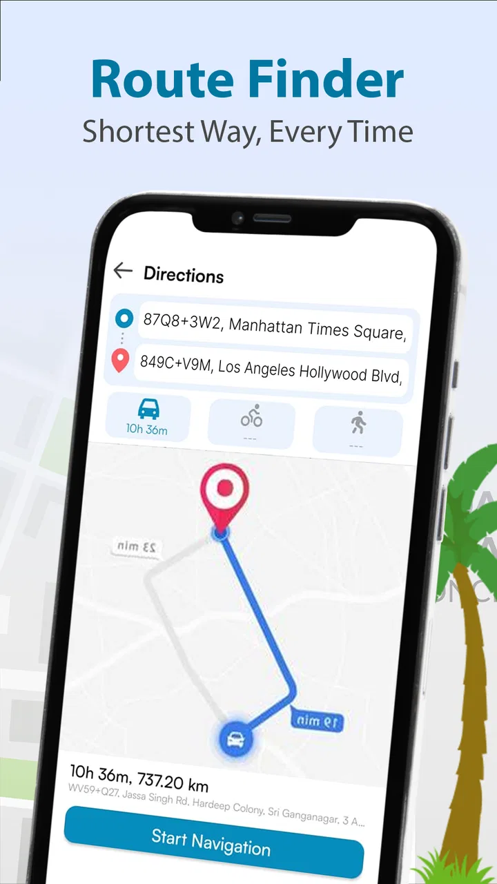
The first strength of GPS, Maps - Driving Directions is its focused purpose. The store summary emphasizes fast route finding, and that description matches the role I would give it: open the app, identify where I need to go, and use the map and directions to support the journey. It does not need to be treated as a complete travel planner for every possible activity. Its value is in getting from one place to another with less fuss.
For me, readability begins before the car moves. I prefer entering a destination while parked, checking the proposed path, and making sure the endpoint is the correct place rather than relying on a last-second correction. This is especially useful for people who find small map labels tiring or who need extra time to interpret a route. A few calm seconds at the start can prevent repeated adjustments later.
The app’s simple positioning also helps users who are easily distracted by busy interfaces. A navigation screen should not make a driver search through unrelated tools while approaching a turn. GPS, Maps - Driving Directions is best approached as a route companion, not as something to explore while driving. I would prepare the destination first, mount the phone securely, and avoid changing settings once the vehicle is moving.
One practical tip is to review the entire route at a standstill before leaving. I look for awkward entrances, divided roads, complicated junctions, and the final approach to the destination. A line on a map can look obvious while zoomed out but become confusing near a shopping area, hospital, apartment complex, or office campus. This habit is useful for anyone, but particularly for drivers who process visual information more slowly.
The app has earned a 4.8 average from around 1.4 thousand ratings, with over 100 thousand installs. Those figures suggest that it has attracted a meaningful group of Android users, but I would not treat popularity as proof that every route will suit every person. Navigation quality depends heavily on the destination, the road layout, the phone, and the user’s own needs at that moment.
Reading the map without overloading your attention
Maps are helpful, but they can also become visually demanding. When I use any navigation app, I try to keep the display at a comfortable zoom and avoid repeatedly pinching the screen. Constant zooming creates extra motor work and takes attention away from the road. With this app, the most reliable workflow is to decide the destination first, inspect the route once, and then let the guidance do its job.
This approach matters for older drivers, people with reduced visual stamina, and anyone using a smaller phone. A small display may make street names or minor turns harder to distinguish, especially in bright light or at night. I would not recommend depending on the screen alone if reading map details requires leaning forward or holding the device unusually close. A phone mount at eye level is safer and more comfortable than handling the device in the hand.
There is also a useful distinction between route clarity and route completeness. A clear line can tell me where the app expects me to go, but it does not replace local judgement. Temporary roadworks, private access roads, confusing building entrances, and restrictions can all make the final few minutes more complicated. I use the map as support for decisions, not as permission to ignore signs or road conditions.
For passengers, the app can be easier to use as a shared planning screen. A passenger can check the destination, watch for the next major turn, or help confirm that the route still makes sense. This is a good arrangement for someone who has difficulty reading small text, managing touch controls, or switching attention between the road and the phone.
Motor effort and touch interaction
Navigation apps place unusual demands on motor control. A user may need to tap a destination, adjust the map, start a route, or recover after an accidental touch. Those actions can be difficult for people with tremors, limited reach, hand pain, or reduced fine-motor precision. My advice is to do the fiddly work before departure and keep the live journey as hands-off as possible.
A realistic example is a driver leaving work in heavy rain. Their hands may be cold, visibility may be reduced, and stopping to correct a destination can be inconvenient. I would search for the location indoors, confirm the route while parked, and only then begin driving. If the destination is a large venue, I would choose the exact entrance or address carefully rather than assuming the first matching result will be the most useful arrival point.
People who use one hand, a stylus, or an alternative input method should test the basic route workflow before depending on it for an unfamiliar trip. The app runs on Android 8.0 and above, which helps users with older devices, but device age can still affect screen responsiveness and comfort. A phone that struggles with touch input is not suddenly made easier to operate by installing a navigation app.
Voice control can reduce touching in some phone setups, but I would not claim that GPS, Maps - Driving Directions itself provides a particular voice feature unless it is visibly available on the user’s device and version. The safest assumption is that the app should be prepared manually while stationary. That is a small limitation in convenience, but it is a responsible way to use any driving tool.
Visual, hearing, and cognitive considerations
Users with visual differences may approach the app in very different ways. Someone with mild difficulty reading distant signs may appreciate having a route overview on a phone, while someone with low vision may find map labels too demanding. I would test the app with the phone’s own display enlargement, contrast, and text settings where available, then check whether the map remains understandable rather than assuming a system setting solves everything.
For users who are deaf or hard of hearing, visual route information can be particularly important, but visual reliance has its own risks. A driver should not stare at the screen to compensate for missing audio cues. The better workflow is to review the route before moving, use a secure mount, and combine the app with visible road signs and a passenger when possible.
Cognitive load is another major issue. A person with attention difficulties, memory challenges, anxiety about unfamiliar roads, or fatigue may benefit from breaking the journey into manageable stages. I would write down or remember a few major landmarks, check the destination area beforehand, and avoid making several route changes at once. The app can support orientation, but it cannot remove the need to make safe decisions under pressure.
One non-obvious advantage of a dedicated map tool is that it can serve as a confidence aid even when I already know part of the journey. I may check the route before leaving simply to understand the final approach. That reduces the mental burden of wondering whether I missed an exit or entered the wrong side of a complex road. In that sense, the app is useful not only for strangers in a city but also for familiar trips with an unfamiliar destination.
Using it across different situations
GPS, Maps - Driving Directions makes the most sense for routine drivers, occasional travelers, and Android users who want a free starting point for route guidance. It is also a sensible option for someone with an older supported phone who does not want to replace the device merely to use a current navigation app. The Everyone age rating makes it suitable for a broad audience, although children should never operate a phone while a vehicle is moving.
Its free price lowers the barrier to trying it. There are in-app purchases ranging from $0.99 to $9.99 per item, so I would check the purchase screen carefully before confirming anything. A free installation does not necessarily mean every optional element is free. This is especially relevant for families, users with limited budgets, and anyone who prefers to avoid accidental spending. I would also make sure the payment confirmation step is understood before handing the phone to another person.
For a daily commute, I would use the app before leaving to compare the expected route with my usual road. The point is not to follow it blindly every morning. Instead, it can help reveal a different approach when the familiar road is slow or unsuitable. If the suggested route sends me through complicated side streets merely to save a small amount of time, I may prefer the simpler road I already know. Route efficiency is not always the same as comfort or accessibility.
For a medical appointment, access needs become more important. I would search for the exact building, inspect the final approach, and allow extra time for parking and walking. A route that ends at a property boundary may be fine for one person but frustrating for someone who needs a step-free entrance, a drop-off point, or help from a companion. The app can guide the vehicle to the area, but I would confirm the venue’s access arrangements separately rather than assuming the map knows them.
For a delivery, service call, or home visit, the app may be useful as a quick destination checker. I would still verify apartment numbers, building entrances, and private roads with the recipient. This is one of the situations where a route line is not enough: the final access point often matters more than the main road. A passenger can help compare the map with visible signs while the driver concentrates on traffic.
Where it compares well with usual alternatives
The usual alternatives in this category often fall into two groups. Full-featured navigation platforms may offer a much wider ecosystem, including traffic layers, public transport planning, business information, saved places, and extensive account-based tools. Simpler map apps may feel less demanding but provide fewer ways to inspect a journey. GPS, Maps - Driving Directions sits closer to the focused end of that spectrum.
I like that focus when my need is direct driving guidance rather than a complete travel dashboard. A less crowded experience can be easier for someone who becomes overwhelmed by many buttons, categories, and notifications. It can also be more approachable for a first-time user who only wants to find a route and leave.
However, people who depend on detailed live traffic intelligence, advanced transit planning, cycling information, walking accessibility details, or a large personal place library may be better served by a more established all-purpose mapping platform. Those tools can justify their extra complexity when a journey involves several transport modes or constantly changing conditions.
The trade-off is therefore not simply “simple versus powerful.” It is “focused route support versus a broader information system.” I would choose this app for a clean, practical starting point, but I would keep another map source available for complex travel planning, unfamiliar public transport networks, or destinations where accessibility details are essential.
Barriers that still affect inclusive use
The biggest barrier is that navigation depends on more than the app. A user may have an older phone, a small screen, limited battery, weak connectivity, or difficulty holding the device in a safe position. The app’s support for Android 8.0 and later is helpful, but it does not guarantee a comfortable experience on every supported handset. Screen size, brightness, touch sensitivity, and mounting options can change the experience considerably.
Another barrier is the gap between reaching a destination and reaching the right entrance. This affects wheelchair users, people with walking limitations, parents with pushchairs, older adults, and anyone carrying equipment. I would not rely on a general driving route to identify curb cuts, lifts, accessible parking, or step-free entrances. Those details should be checked through the destination itself or with a person who knows the site.
Weather and lighting also matter. Glare can make a screen difficult to read, while night driving can make bright displays distracting. I would adjust the phone before setting off, keep the display from becoming the main focus, and stop safely if I need to investigate a confusing route. A navigation app should reduce uncertainty, not encourage risky interaction.
There is also the human barrier of confidence. Some people find maps intimidating even when the route is correct. I recommend a short practice run in a familiar area: set a nearby destination, review the route while parked, and observe how the app presents the journey. Practising with low stakes is more useful than opening it for the first time during a stressful trip.
The developer, App Aviator_GPS Maps & Navigation, presents a product that is easy to understand at a glance, but inclusive design is judged in the details of use. I would like every user to test the exact controls, text size, and route presentation on their own phone before treating it as a primary navigation aid. That is not a criticism unique to this app; it is an essential precaution for any tool used in a moving vehicle.
Who should use it and who should look elsewhere
I would recommend GPS, Maps - Driving Directions to someone who wants a free Android navigation option for ordinary driving, prefers a focused interface, and is comfortable preparing the route before setting off. It is particularly appealing for users with supported older devices and for passengers who want to help with route checking without managing a large travel ecosystem.
I would be more cautious about recommending it as the only tool for people who need verified accessibility information at the destination, highly detailed traffic decisions, public transport planning, or a deeply personalized map library. In those cases, a larger navigation platform may be worth the additional visual and functional complexity.
I would also skip relying on it alone for long, unfamiliar journeys if I could not safely check the phone, confirm the final entrance, or recover from a wrong turn. The app may still be useful as one part of the plan, but a passenger, printed notes, or a second trusted source can provide valuable backup.
My final view on accessible everyday navigation
After using GPS, Maps - Driving Directions as a practical route tool, I see its strongest quality in its clear purpose. It is not trying to be every kind of travel app at once. For many drivers, that can make the basic task of finding a route feel less intimidating. The free entry point, broad Android compatibility, and strong user response make it a reasonable app to try.
Its accessibility value is more conditional. It can support different abilities when the user prepares the route, secures the phone, adjusts the device, and treats the map as assistance rather than a substitute for road awareness. It is less suitable when someone needs detailed information about physical access, complex transport choices, or highly specialized guidance.
My recommendation is to use it as a calm, prepared driving companion rather than an automatic answer to every navigation problem. Test it on a familiar trip, check how comfortably you can read and operate it, and decide whether its focused approach matches your needs. For straightforward journeys, I think it is a worthwhile free option. For demanding or accessibility-sensitive travel, I would pair it with information from the destination and, when necessary, a more comprehensive navigation alternative.
That balanced role is where the app works best for me: quick route support, sensible preparation, and enough flexibility to help a wide range of users without pretending that one map can solve every real-world barrier.
FAQs for GPS Navigation: Maps & Route
01What features does GPS, Maps - Driving Directions offer?
GPS, Maps - Driving Directions offers a variety of features including real-time navigation, voice-guided directions, traffic updates, and route planning. Users can also access offline maps, explore points of interest, and customize their routes based on preferences such as avoiding toll roads or highways.
02Is GPS, Maps - Driving Directions available offline?
Yes, GPS, Maps - Driving Directions provides offline map access. Users can download specific areas to their device, allowing for navigation without an internet connection. This feature is particularly useful for traveling in areas with limited or no network coverage.
03How accurate is the traffic information in GPS, Maps - Driving Directions?
The app uses real-time data and multiple sources to provide accurate traffic information. It updates continuously to reflect current road conditions, helping users avoid congestion and find the fastest routes. However, traffic conditions can change rapidly, so occasional discrepancies may occur.
04Are there any costs associated with using GPS, Maps - Driving Directions?
GPS, Maps - Driving Directions is free to download and use, but it may contain in-app purchases or advertisements. Users can opt for premium features, such as ad-free experiences or advanced navigation tools, which may come at an additional cost.
05How does GPS, Maps - Driving Directions ensure user privacy?
The app follows strict privacy guidelines to protect user data. It requires certain permissions to function, such as location access, but these are used solely for enhancing navigation accuracy. Users can adjust privacy settings within the app to control data sharing and permissions.
Pros
- User-friendly interface for easy navigation.
- Real-time traffic updates reduce delays.
- Offline maps available for data savings.
- Voice-guided navigation enhances safety.
- Customizable map views for preferences.
Cons
- Consumes significant battery power.
- Occasional GPS signal drop-offs.
- In-app ads can be intrusive.
- Data-heavy; requires ample storage.
- Limited features in free version.

GPS Navigation: Maps & Route
Gallery